Transforming Norwegian Forest Monitoring
with LiDAR-based Deep Learning
"By replacing manual classification with automated processes, we provide forest managers with timely and reliable data for decision-making."
Background
Accurate and up-to-date mapping of tree species locations is key in ensuring sustainable use of resources and successful biodiversity conversation. The current method of forest mapping relies heavily on human input, which can lead to errors due to the manual analysis of Earth observation data. This outdated approach often results in incomplete and inaccurate forest inventories, making it challenging for policymakers to make well-informed decisions.


The Problem
The main challenge for S[&]T was to create an innovative approach in forest mapping that not only improves accuracy, but also significantly reduces costs. The current method is predominantly centered around human-driven data analysis and interpretation, and considering the vast extent of Norway's forests, the procedure becomes time-consuming and costly, leading to infrequent updates and potential discrepancies between mapped data and actual forest conditions.
The Solution
With extensive experience in remote sensing and space data analytics, we embarked on an innovative project in collaboration with the ESA SENTREE initiative to create a solution for mapping the distribution of tree species in Norway. By utilising LiDAR (Light Detection and Ranging) data and advanced deep learning algorithms, our goal at S[&]T was to transform forest inventory practices and facilitate more efficient forest management.
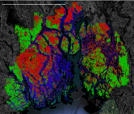
To address the challenges found, S[&]T has developed a deep learning-based model that utilises LiDAR data to accurately predict the distribution of key tree species such as Norwegian Spruce, Scots Pine, and Birch across Norway. Deep learning is able to recognise contextual and texture information, which opens up opportunities for better utilisation of the information available in the very high-resolution imagery data and open lidar data products. By leveraging this technology, we have generated a comprehensive tree species map for the entire country.
R ⇢ Norwegian Spruce | G ⇢ Scots Pine | B ⇢ Birch