Unless we want to go back to the Middle Ages (quite literally) - we have to be prepared
Navigation systems such as the American Global Positioning System (GPS) and the European Galileo system are already deeply nested in our modern economy. The use of these satellite constellations (called GNSS – Global Navigation Satellite Systems) goes much further than the well-known consumer vehicle navigation systems. For example, the positioning functionality of these systems is in use in aeronautical precision landing systems, asset management and autonomous vehicle technology. However, satellite navigation systems do not only provide positioning: they also provide accurate timing information, making it possible to synchronize devices across the globe to within several nanoseconds.
This technology is nowadays essential for operation of national power grids, international finance, global communication (internet, mobile networks) and the Justice and Security domains too. Disturbance – or even worse – failure of GNSS-systems could/will have far-reaching consequences.
This current and increasing reliance on Global Navigation Satellite Systems (GNSS), as how these systems are collectively known, also increases the awareness of their (intended and unintended) shortcomings and vulnerabilities.
These openly sent Global Positioning System Signals can be disturbed easily, intentionally and unintentionally, by man-made devices and by natural phenomenons. Major risks include:

Jamming
is a form of electronic countermeasure that intentionally
sends out radio frequency signals to interfere with the operation by saturating
the receiver with noise.
It’s relatively easy and cheap to do.

Spoofing
is a situation in which a person or program successfully identifies as another by falsifying data, therefore giving false coordinates, resulting in missing information or navigational hijacking. This requires more technical knowledge, but with the technological advancements it’s easier to do by the day, and harder to recognize.

Disturbances
of the GPS navigation can also be caused by
nature's forces, like our Sun and other space phenomenons. Space weather includes any and all conditions
and events on the Sun, in the solar wind, in near-Earth space and in our upper
atmosphere that can affect spaceborne and ground-based technological systems
and through these, human life and endeavor.
A robust navigation system, which is able to deal with external threats and dynamics while always providing the most reliable available navigational information – is the future. We are now combating these problems from all sides: hardware, software, tools and collaborations. A consortium cluster was started with S[&]T as a central coordinator in-between multiple teams. We are calling it STRoNG: S[&]T Robust NaviGation.
SkyDec provides design and integration of naval navigation systems. CGI is a multinational software company who currently leads the Galileo Public Regulated Service (PRS) receiver development. NEDAERO is a company specialized in aircraft avionics’ design and refurbishment. Finally, S[&]T acts in the role of R&D specialist, with a significant history in GNSS signal quality measurement and interference detection.
And now a little about the projects that are combating together the shortcomings of GPS signals.
Antenna: GRATE
Making sure that the position is accurate and is not disturbed, S[&]T is working with Astron on a small smart GNSS receiver with a smart antenna, that can monitor the quality and protect the navigation signals that are sent to your device. Using ASTRON’s knowledge of so-called phased arrays, the GRATE (which stands for GRound-station Array TEchnologies) receiver will use advanced beam forming techniques to focus the antenna on the visible navigation satellites. This makes it possible for the antenna to become ‘selectively deaf’ to other directions, such as towards sources of interference.
Receiver: ANTIFERENCE
It is easy to disturb the signal, but it is hard to detect that a receiver is disturbed by a malicious agent. One sure way is to look at the antenna signal of a receiver, and then to look for the tell-tale signs in that to see if somebody is trying to over-take the signals. Detection is one thing, but classification and mitigation of these situations is another thing. The consortium OHB (Austria), Integricom (NL) and S[&]T (NL) will develop a novel technique that is completely based on Machine Learning: to detect, classify and mitigate these attacks on the signal integrity.
Navigation model: FOG-D
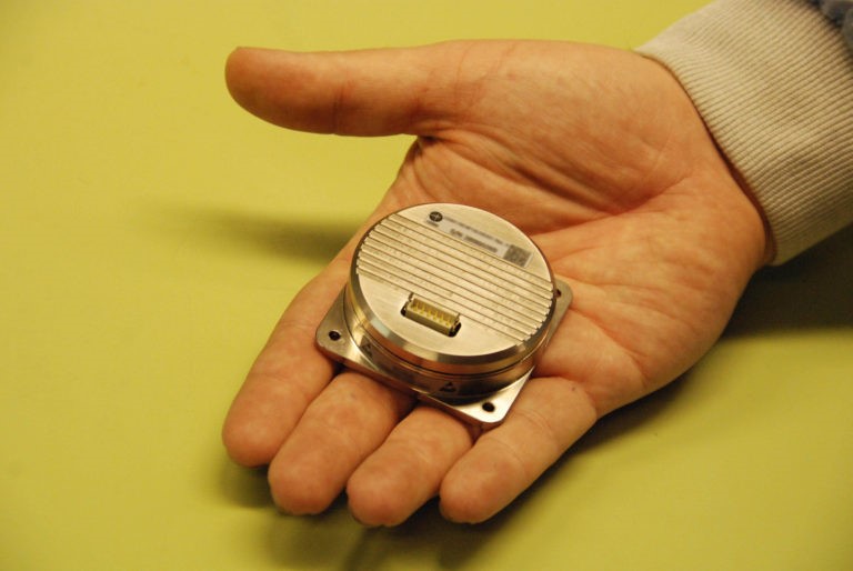
Fiber Optic Gyroscope - Digital - working with NedAero who already made the Print Circuit Board prototype based on S[&]T's design. The navigation system is intended to contain an Inertial Measurement Unit (IMU) as a central subsystem. This combination of gyroscopes and accelerometers provides information on the IMU’s instantaneous accelerations, which can be integrated to yield velocities. A second integration returns the IMU’s position. NEDAERO has developed a Fiber Optic Gyroscope (FOG), which in combination with off-the-shelf accelerometers may form the IMU. NEDAERO’s FOG is currently already included in the Airbus A350 jet aircraft. It is characterized by its low drift rate (typically ~ 0.1° / hr) and long lifetime due to a lack of mechanically moving parts.
Space weather monitoring: DISTURB
Stands for Disturbance-detection by Intelligent Solar radio Telescope of (Un)perturbed Radio-frequency Bands, is a system that will monitor radio emissions from the sun to detect Solar Radio Bursts. During the DISTURB project, we at S[&]T designed a system that can monitor the sun 24/7 and automatically send out warnings if solar interference is detected. This involved coming up with (amongst many other things) new antenna concepts based on technology developed for astronomy, and automatic data analysis methods.
GNSS - Centre of Excellence
Conclusion
There is a growing number of risks in the GNSS domain, especially because of our growing dependency on its navigation and time synchronization. These risks are identified in the Dutch Space industry, and there are a number of developments on their way to make the GNSS-receivers and the whole of the navigational systems more robust and reliable. With these efforts we are on our way to better communication, more stable electricity networks and always correct position and time determination.
Can't do it all alone!
We are happy to work together with this consortium of grate (!) partners:

If you want to read even more about Galileo, check out this superb article about it over at SBIC Noordwijk.